The Philippines faced its second powerful cyclone in a single week as Typhoon Fung-wong crossed Luzon with destructive winds and a broad rain shield. The storm arrived soon after deadly Typhoon Kalmaegi, compounding damage across the archipelago. Government agencies and local responders moved millions of people into safer locations, yet the combination of overflowing rivers, storm surge, and landslides still caused significant destruction, transport disruption, and extended power loss.
Track, Strength, and Hazard Footprint
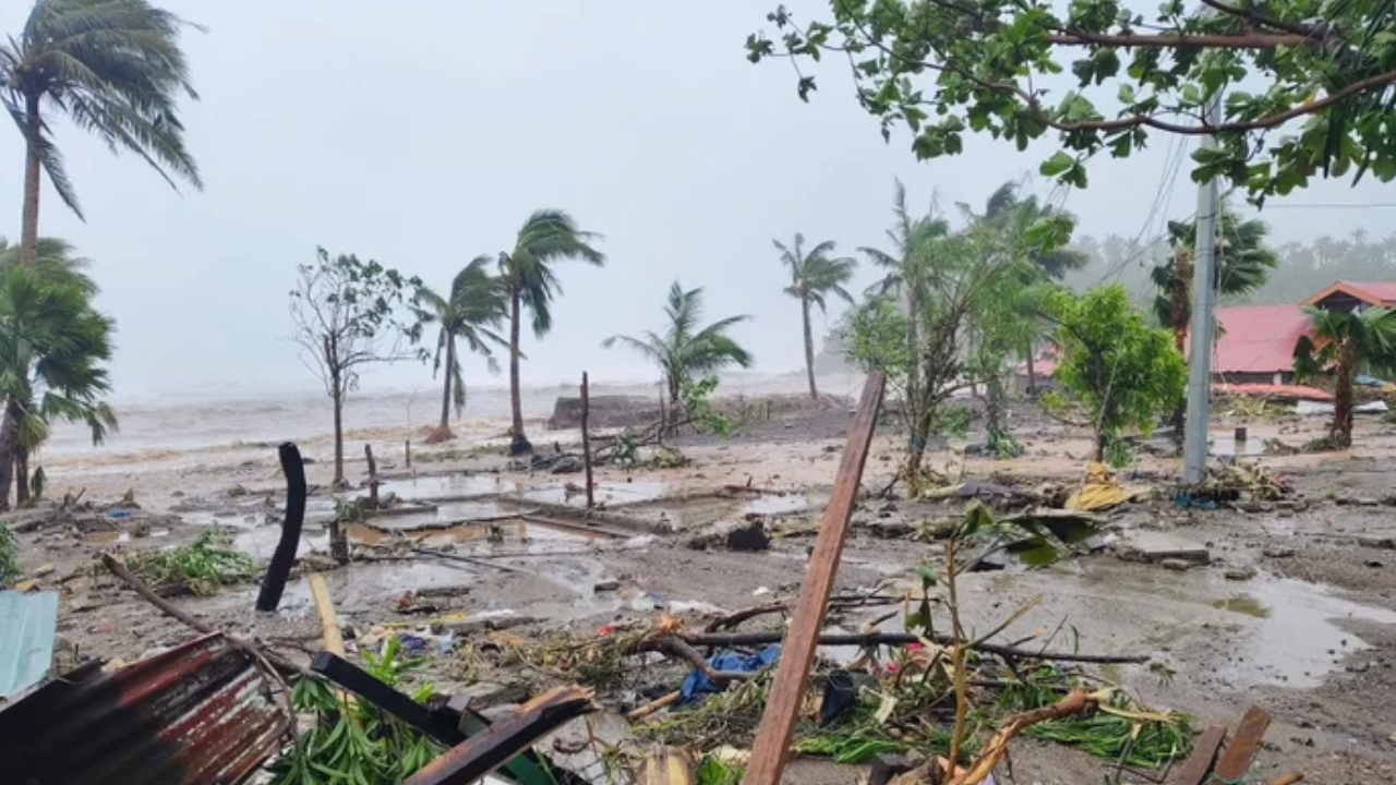
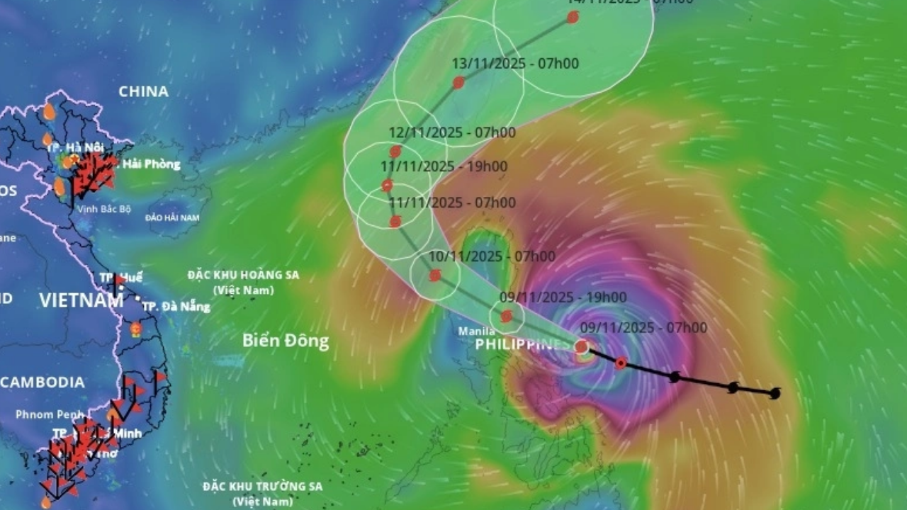
Fung-wong made landfall in the coastal municipality of Dinalungan on the main island of Luzon. At landfall the system carried sustained winds near 185 kph and higher gusts. As the circulation moved across mountainous terrain in northern Luzon and the agricultural plains to the south, wind intensity weakened, but the storm’s large rain bands continued to deliver hazardous downpours long after the center passed. The footprint spanned much of the archipelago, exposing communities far from the eye to flooding, swollen waterways, and landslides.
Quick Summary
Item |
Details |
|---|---|
Storm Name |
Typhoon Fung-wong local name Uwan |
Landfall |
Sunday night at Dinalungan, Aurora province, Luzon |
Peak Winds |
Sustained up to 185 kph with gusts up to 230 kph |
Evacuations |
About 1.4 million people before landfall |
Immediate Impacts |
Floods, landslides, power cuts across multiple provinces |
Casualties Reported |
At least two deaths as per early reports |
Areas Still at Risk |
Northern Luzon including metropolitan Manila due to lingering rain |
Next Areas of Concern |
Taiwan underway preparations and selective school closures |
Official Site |
PAGASA Weather Updates https://www.pagasa.dost.gov.ph |
Evacuations and Immediate Protective Actions
Authorities directed a large scale evacuation before landfall. Roughly 1.4 million people sheltered in public facilities such as gymnasiums and theaters or relocated to the homes of relatives. By Monday morning hundreds of thousands remained in evacuation centers while local governments assessed damage, cleared roads, and checked for isolated households. The rapid movement of people reduced exposure to the most dangerous conditions, yet consistent rain continued to test levees, drainage networks, and urban flood control.

Damage Overview and Casualty Reports
Early reports confirmed at least two fatalities. One person drowned in Catanduanes province. Another victim was recovered from a collapsed structure in Catbalogan City where debris pinned residents during peak winds. Officials also listed around 1,000 houses as damaged. Some communities remained cut off by landslides on mountain roads, delaying rescue and relief until conditions allowed teams to enter safely.
Flooding, Power Loss, and Transport Disruption
More than 130 northern villages reported flooding, with some families trapped on rooftops during sudden overnight rises in water levels. Power grids in several provinces failed as transmission lines and local distribution systems sustained wind and debris damage. At one point, estimates suggested about three million people without electricity. The Civil Aviation Authority and airlines canceled more than 325 domestic and 61 international flights from the weekend into Monday. The coast guard halted sea travel due to dangerous waves, leaving thousands of passengers and cargo workers stranded at ports. Road movement was further constrained by downed trees, toppled poles, and temporary closures at river crossings.
Impact on Daily Life and Public Services
Local governments suspended classes and many government offices through midweek to reduce travel during cleanup and restoration work. Relief agencies prioritized potable water, ready to eat food, medical assistance, and temporary shelter materials. Families queued at evacuation centers for essentials while utilities coordinated staged power restoration based on safety checks and available crews. Health facilities faced strain from flood related illnesses, injuries from debris, and the need to maintain cold chain for medicines despite intermittent electricity.

Response Coordination and Resource Pressures
National and private sector partners concentrated resources on Fung-wong while still managing ongoing recovery in areas struck by Kalmaegi, particularly Cebu and Davao. A 24 hour operations center near Manila coordinated logistics, information flow, and allocation of relief stocks. Responders flagged that funding and supplies were under pressure after multiple disasters within seven weeks, which included four major typhoons and two earthquakes. Authorities urged continued vigilance even after the center of Fung-wong exited into the South China Sea due to lingering rainfall and landslide risk.
Taiwan Readies for Impacts
As the storm moved over water, Taiwan prepared for heavy rain and strong winds, especially in eastern counties such as Hualien. Local governments announced selective school closures and evacuation advisories for flood and landslide prone zones. Cross strait ferry and air services reviewed schedules based on changing weather bulletins.

Climate and Infrastructure Context
The Philippines sits in the world’s most active tropical cyclone basin. Warmer oceans provide additional energy for rapid storm intensification and broader rain shields. Urbanization, clogged waterways, and settlement patterns in low lying zones amplify flood exposure. The sequence of Kalmaegi followed by Fung-wong demonstrates how back to back systems can exhaust relief capacity, erode embankments, and saturate soils. These combined factors increase the chance of secondary hazards such as delayed landslides even after clear skies return.
Safety Tips for Residents After the Storm
- Stay away from floodwater which can conceal open manholes, sharp debris, and live wires.
- Use battery powered lights when possible and avoid using generators indoors to prevent carbon monoxide buildup.
- Boil water or use purification tablets until authorities confirm potable supply.
- Photograph damage before cleanup for insurance or assistance claims and keep receipts for repairs.
- Listen to official advisories regarding bridge safety, road reopenings, and return to homes from evacuation centers.
What To Watch Next
Monitor weather bulletins for continued rainfall alerts across northern Luzon including Metro Manila. Expect staggered restoration of power and water. Transport services will resume progressively as inspections finish and debris is cleared. National agencies will publish damage assessments that guide future financial assistance and reconstruction priorities. Communities upstream and downstream of major river systems should maintain readiness for controlled releases from reservoirs or delayed run-off from saturated catchments.
Frequently Asked Questions
1. Is it safe to return home if the eye has passed
Not immediately. Rain bands and swollen rivers can trigger flash floods and landslides after the center exits. Wait for clearance from local authorities before traveling.
2. How long will power restoration take
Time frames vary by province and the extent of line damage. Utilities prioritize hospitals, water systems, and dense neighborhoods first. Prepare for several days of intermittent service in hard hit areas.

3. What should I do if my home is flooded
Turn off electricity at the main breaker if safe to do so. Move to higher ground, avoid contact with floodwater, document damage with photos, and contact local disaster offices for shelter and assistance information.
4. Are flights and sea travel operating
Many flights were canceled and sea travel was restricted during peak conditions. Check with airlines, ports, and the coast guard for the latest notices before heading to terminals.
5. Where can I find official weather and hazard updates
Use PAGASA for track and rainfall advisories and your local disaster risk reduction office for evacuation, road, and shelter information.
Conclusion
Typhoon Fung-wong delivered a wide arc of wind and water hazards across the Philippines at a time when communities were still recovering from Kalmaegi. Large scale evacuations prevented higher loss of life, yet extensive flooding, landslides, power cuts, and transport disruption underscored the vulnerability of densely populated and low lying areas. Continued caution is essential, since residual rains and unstable slopes can produce new emergencies. Coordinated response, targeted funding, and investment in drainage, early warning, and resilient infrastructure will be central to reducing the impact of the next storm.
Official Site for Updates:
PAGASA Weather Updates https://www.pagasa.dost.gov.ph
For More Information Click HERE